Experts in Environmental Modeling.
From watersheds to rivers to estuaries to coasts, we model complex environments and develop innovative data visualization and analysis.
We assess environmental impacts to provide our clients with answers backed by thoughtful and thorough scientific investigation that we proudly stand behind.
What Our Expertise Supports
Our modeling and analysis has supported permitting and compliance efforts for many types of projects in or near water. If there’s a question about potential environmental impacts, we’re happy to have a conversation about it — whether or not modeling is the best path forward. Examples of permitting applications for our work include:
- Industrial discharge permitting
- Stormwater Phase II General Permits for MS4s
- Mixing Zone determinations
- 316(a) discharge permitting
- Mixing Zone determinations
- 316(b) intake permitting
- Environmental Impact Assessments related to dredge and fill operations
- Wetlands construction permitting
- Waste Load Allocation determinations
- Facility operation schedules
- FEMA permitting for work within Special Flood Hazard Areas
- Massachusetts Chapter 91
Our modeling can be applied to support important decisions related to design and maintenance of infrastructure.
- Flood impacts
- Offshore and overland wave impacts
- Scour and sediment transport
- Outfall location selection
- Structural configuration to achieve mixing
- Hydrology and hydraulics
- Sizing and low chord elevation
- Scour and sediment transport
- Hydrology and hydraulics
- Dam breach analysis
- Sediment transport associated with dam removal
- Sizing for water quality treatment
The surrounding environment can have a big influence on the performance of a facility. Our expertise can help optimize how a facility interacts with the environment.
We model surface water hydrodynamics, groundwater behavior, and coastal processes. By understanding and predicting ambient conditions, we can guide our clients to make the best possible decisions about where to site their facilities to minimize environmental impacts and maximize performance.
We use programming to automate many of the steps in modeling. As a result, we can set up model scenarios quickly and post-process the results with equal efficiency. This allows us to test more scenarios in less time and arrive at the best possible answers for our clients.
For many of our clients, it’s no longer adequate to make important, long-term decisions based on environmental data from the past. Climate change has invalidated the status quo.
Our modeling can take regional climate predictions for sea level rise and future storm characteristics and bring them down to a site-specific resolution. In doing so, we take abstract concerns and convert them into actionable data for planning.
We can evaluate the resiliency of key assets that could be impacted by any of the following:
- Flooding from rising sea levels and exposure to wave action
- Flooding from increased precipitation
- Flooding from changing groundwater levels
Climate change is altering the natural environment. Estuaries, wetlands, and rivers are evolving and disappearing in response to climate change. Our services can help private and public property owners evaluate:
- How natural resources will evolve in response to climate change
- How adaptation strategies can help mitigate evolution due to climate change
Environmental modeling is based firmly in science, but it takes professional interpretation to set up a model and apply the results. Because the process involves assumptions and interpretations, there can be room to question the findings of a modeling study. We provide independent reviews of work done by other professionals in our field, and we help our clients advocate for their interests from a strong technical position. Here are a few types of concerns we can investigate:
Regulatory reviews are designed to evaluate how a project will impact others, but the regulator does not always account for the risk of harm to an interested party. If you believe you’re at risk as a result of a proposed (and potentially approved) project, we can take available documentation for the project and assess whether there are valid technical concerns about how the project might impact your interests.
On the other side of the coin, sometimes the process of getting regulatory approval for a project can be unnecessarily onerous. We’re here to help in that case as well. We can develop a technically sound argument that explains why certain analyses or efforts aren’t necessary to evaluate the impacts of a proposed project. If additional analysis is unavoidable, we’ll work to find the most efficient path forward.
Regulatory agencies use regional models to make determinations that impact properties within the region. Sometimes regional models are missing critical local information. We can review the regulatory model together with information about a site to determine if local information is missing, and whether that missing information would change how a given regulation is applied to a site. One example might be a FEMA floodplain model that’s missing a critical flow-control structure impacting the base flood elevation. Another example could be a TMDL model that’s missing a piece of local information critical to properly assigning the waste load allocation.
CORMIX: Mixing Zone Study
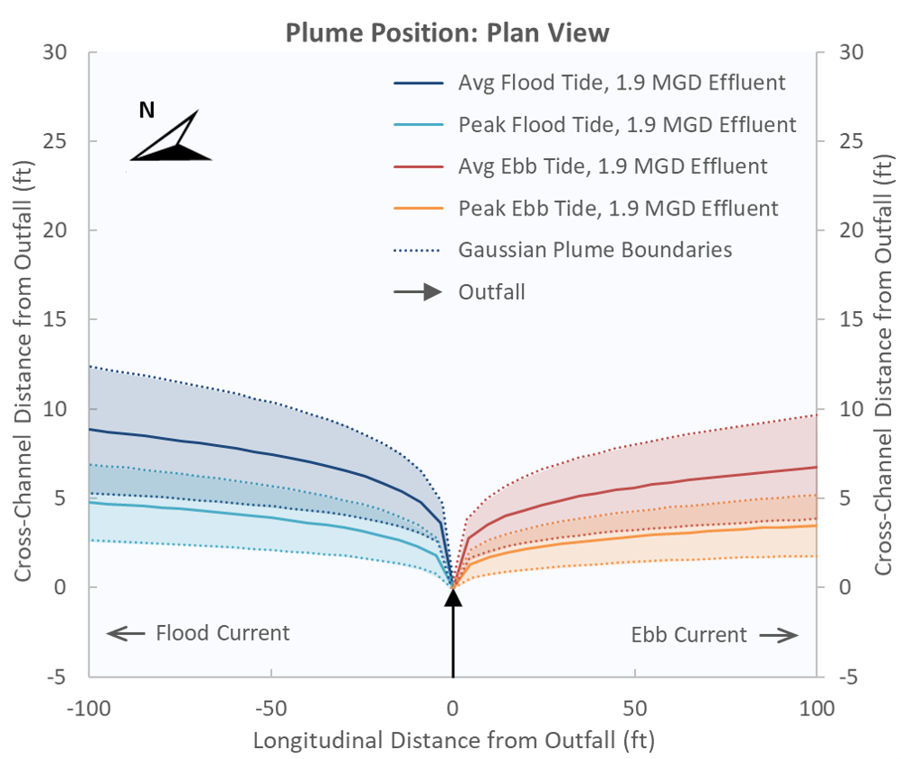
HWR used CORMIX to perform mixing zone modeling for a proposed outfall within a tidal waterbody. HWR evaluated multiple steady-state CORMIX scenarios to capture the range of expected tidal conditions.
To comply with the state general permit under NPDES, the mixing zone for the new outfall had to fit within a 100-ft radius cylinder. HWR found that effluent would be diluted by more than a factor of 20 at the cylinder boundary, meeting water quality standards.
Hydrology & Hydraulics: Base Flood Elevations
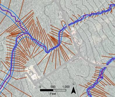
In support of a wetlands construction permit, HWR modeled the hydraulic behavior of two creeks without established base flood elevations (BFEs) in the effective FEMA Flood Insurance Study (FIS).
HWR used HEC‑RAS to model open-channel hydraulics during the 100-year storm event and map the BFEs from the headwaters of each creek to the downstream point where the effective FIS specifies a BFE.
Sediment Transport: Offshore Cable Laying
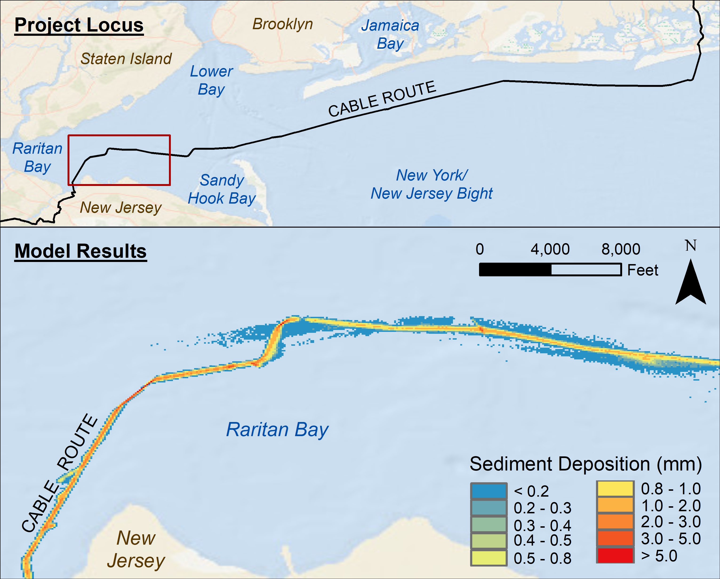
In support of the permitting of an offshore cable between New York and New Jersey, HWR developed a sediment transport model using ADCIRC and PTM.
The model domain included all of Raritan Bay, all of Lower Bay, and part of New York Bight. HWR's model was coupled to the NYOFS model and used to predict suspended sediment concentrations and depositional thicknesses along the length of proposed excavation. Read the study report here.
Water Quality: Outfall Relocation
In support of an outfall relocation study, HWR developed a 3D hydrodynamic harbor model using EFDC.
The model predicted how far-field mixing would change effluent concentration over space and time, and HWR applied the model to understand which outfall location would provide the most dilution. HWR developed customized metrics and informative visuals to better understand and rank potential locations throughout the study harbor.
Groundwater: Chronic Flooding Investigation
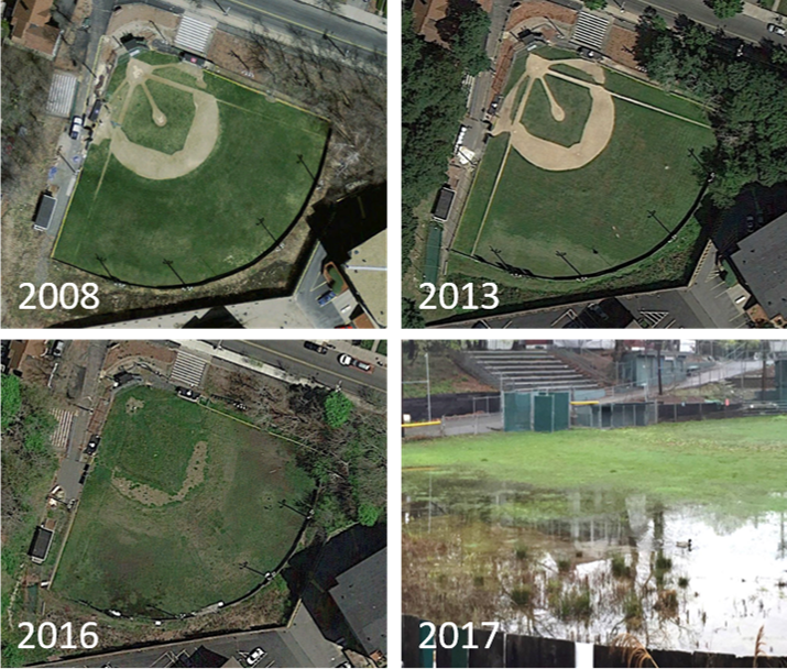
HWR investigated chronic flooding at a Massachusetts baseball field. HWR identified possible flooding sources after reviewing local topography, historical aerials, soil boring logs, and the configuration of the surrounding stormwater and sewer systems.
HWR’s primary conclusion was that recent efforts by the city to limit groundwater infiltration into the sewer system had caused the water table to rise, impacting the low-lying baseball field.
Stormwater: Water Quality Compliance
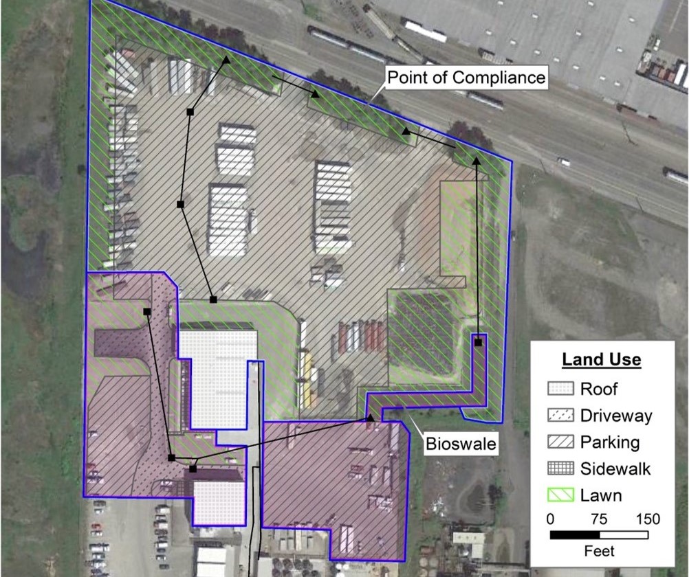
HWR provided modeling support services for the redesign of stormwater infrastructure at an industrial site in Washington State.
HWR applied the Western Washington Hydrology Model, a modified version of HSPF, to evaluate the water quality performance of existing and proposed stormwater BMPs relative to regulatory thresholds established by the Department of Ecology.
Oil Spill Modeling: Massachusetts Bay Test Case
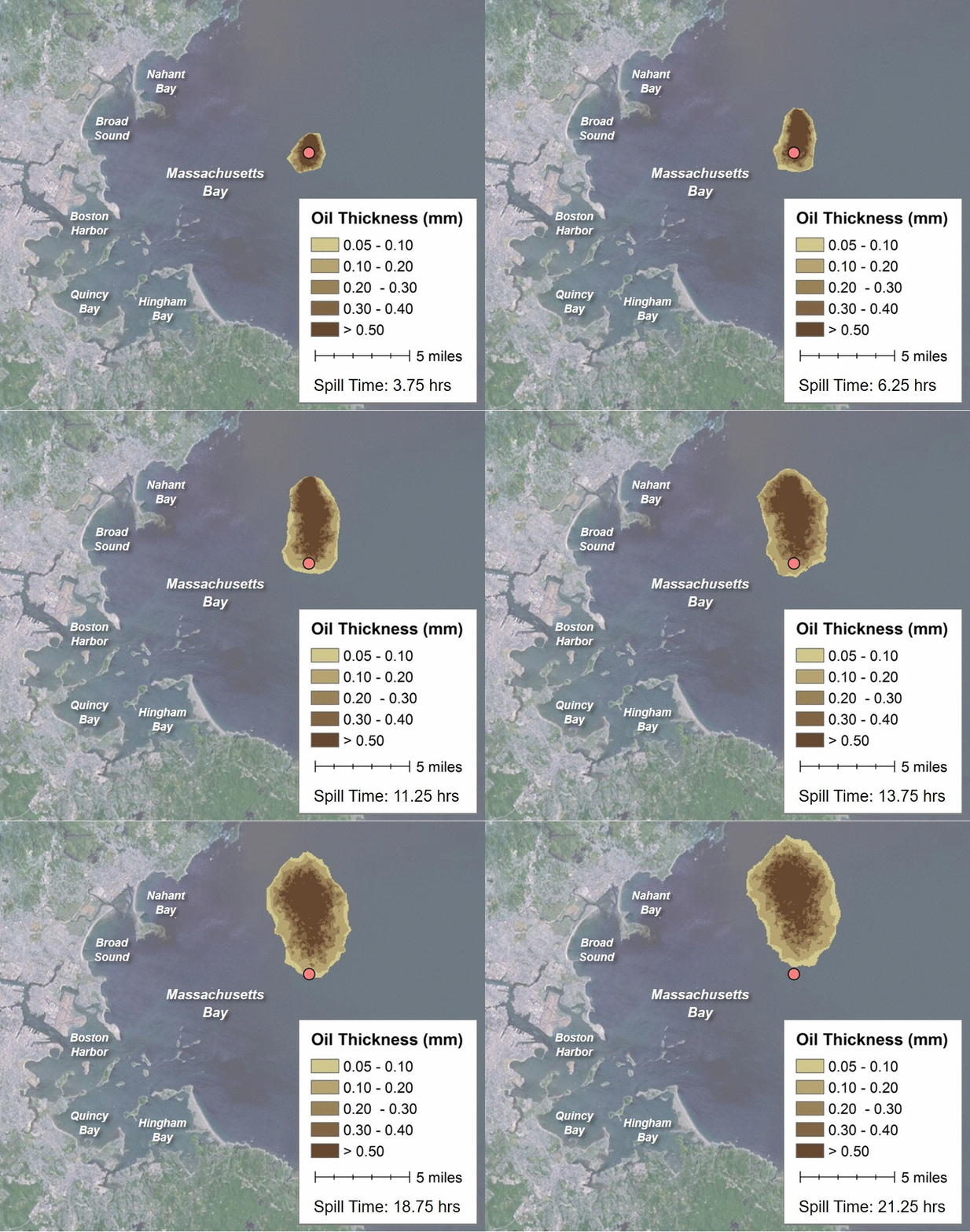
HWR has developed pre- and post-processing tools that work with NOAA’s oil spill trajectory model GNOME. The tools allow HWR to use results from existing hydrodynamic models such as ADCIRC to simulate how an oil spill would move on the surface of a waterbody and interact with the shoreline.
HWR is continuing to improve our tools and visuals, with plans to incorporate additional hydrodynamic models and the influence of wind and weathering on oil spills.
Web-Based Tools: Water Resources Report
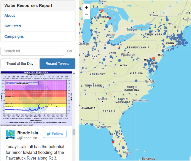
HWR developed and maintains the Water Resources Report, a website that tracks the Twitter activity of regulators and stakeholders related to water resources across the United States. When someone tweets about a river, lake, stream, or coastal region, the Water Resources Report puts it on a map.
You can use the Report to see what’s happening near you and throughout the country. Check it out and see what got spotlighted as our Tweet of the Day !
